

For Episode 53 we explored Darwin then sailed to the Cobourg Peninsula for some awesome Barramundi Fishing, before transiting across the top of Arnhem Land.
In the end we
were in Gove having an excellent 10 days with the friendly locals who took us
spearfishing and showed us the sights around Gove and Nhulunbuy.

Our location for this
episode

Our route for this
episode
Despite the
bulk of the cruising fleet deciding to leave Gove to tackle the 350nm+ Gulf of
Carpentaria crossing on Friday the 4th November, we decided to wait and
enjoy the weekend with friends in Gove.

Returning the favour – a
fun Sunday arvo sail with a stack of
Gove locals who looked after us soooo well….
Gove locals who looked after us soooo well….
We even spent
an awesome Monday with friends Chris & Phoebe and didn’t end up leaving
Gove until 10am on Tuesday 8th – 4 days behind the rest of the
fleet.
However we
had received reports of them coping a battering as they motored into the east
winds and swell. We were glad to have left when we did.
Our first 24
hours out was a dream run with north winds of around 10-12 knots and we sailed
due east towards Weipa at 6-7 knots boat speed.
By midday on
day 2 we had sailed over half way across in just 26 hours and were so happy.
We picked up
a hitchhiker on the first afternoon – a Booby Bird.
It sat on our solar panels until 10am the next
day when we surmised they got too hot to stand on and it flew away.

The arvo of
day 2 saw the wind slowly drop and by sunset we had sails down and were just
finishing packing away the sheets (ropes) by the time the myriad of colours from
the sunset covered the skyline.

We
fortunately decided to motor NE and were very glad to be north of the rhumb
line by daybreak.
Before
daybreak on day 3 it was sails up again as we sailed east towards Weipa in the light
NNE winds and a great sunrise.

The next 24
hours was a zig-zag trail of motoring, sailing and motor-sailing as the wind
rose and fell and changed directions every few hours.
We were excited to see Sailfish with their fins out on display on the surface as they swam past Lorelei 3 times during the day and even once at night.

We were excited to see Sailfish with their fins out on display on the surface as they swam past Lorelei 3 times during the day and even once at night.

Each time we
sailed we were tight-on and pointing into the wind so it was a nice change to
get within 50nm of the QLD coastline and have afternoon sea breezes which had
us sailing off-the-wind for the afternoon and evening of day 3.
So we changed
destinations and instead of sailing for Weipa we headed north towards Cape
York.


To be honest
we were torn where to stop and play.
There were a
bunch of amazing river systems on the Cape’s west coast that were reported to
be excellent fishing, but it was now closed Barramundi season.
The other
option was to round the cape, explore the Cape’s east coast and start fishing
and diving our way south.
Additionally
there were the Torres Islands to also explore.
Either way we
only had limited time as the cyclone season was fast approaching and we still had
to get a long way south down the east coast before the end of the year.
We couldn’t
do it all so we let the weather dictate our plans.
As the
westerly winds were prevalent, we ruled out the west coast and instead sailed
all the way to top of Cape York which also happens to be the tip of Australia.
Just as we
entered the straight approaching the Cape, we had an Australian Border
Protection helicopter fly up to us and hover over the stern of Lorelei.
We have been
flown over by scores of Border Protection planes but this was our first helicopter
experience.
We had a chat
on the VHF before they buzzed over to the power boat that was travelling along
next to us.

We stopped
overnight at the Permission Islands after arriving at 4pm on day 4 of the
crossing.
We were
stuffed!!! So we ate a meal, enjoyed another great top-end sunset and were
asleep by 7:30pm.


The next
morning we travelled the last 10 miles to the tip.
It took us 3
attempts to enter the bay next to the cape as it was so shallow and we nearly
ran aground more than once.
Finally we
found a shallow path in and anchored in only a few meters of water.
We dropped
the tinny in and within 30 minutes were standing on the tip of Australia.


Just as we
were packing our camera tripod away, a group of 6 border protection staff came
down to the tip.
We thought
“Heck, what have we done wrong???”
We jokingly
put our hands in the air and said
“Don’t shoot
we didn’t do it”
When they
started laughing we knew we weren’t in trouble.
In fact it
was 3 friendly Aussie staff with 3 equally friendly visiting PNG customs/border
staff who wanted to experience the tip just like we did.
So Paul took
their photos for them with their cameras – and took one with his….

We walked
back up the track to view the cape from higher up and to see the many cairns
(piles of rocks) that have slowly built up over the years from the many
tourists that visit the cape in the dry season.
Being the
start of the wet season, we had the place all to ourselves after the Border
Force crew left.

Note York Island in the
background to the left – more on that later…..

Looking out
over the bay where Lorelei was anchored was spectacular.

There was a
brass dial at the top showing direction and distances to the iconic locations
of the area and famous cities worldwide.
It was
interesting to see the 3 that we highlighted with a yellow arrow.
They were
Darwin – 1300km were we were 6 weeks prior, Bali – 3000km where we were earlier
in the year and Singapore - 4500km were we were exactly 12 months ago to the
day.

Whilst at the
cape, we could look across the small channel and see York Island.
We noticed a
few large cairns on the summit and that was like a red rag to a bull for Paul.
So that
afternoon at 3pm we took the Tinny over and climbed to the peak of
York Island.
York Island.
It not only
gave us awesome views of the surrounding area but also fantastic views looking
down over the cape.

Even at only ¼ the way
up, the view to the cape was excellent.
From half way
we could look over and see Erebus Island next to York Island.

We set the
tripod up above a cliff face at the top overlooking the cape and took some
photos in the afternoon glow from the setting sun.

Looking back towards
Cape York and the tip of Australia’s mainland
Whilst Lisa
was content with that, Paul wanted to continue a little further up to view the
cairns that were on the summit.

We made it
back down just in time to view the sunset from the rocky point at the end of
the beach and opposite the tip.


Note Lorelei at anchor
on the left in the photos above and below

With bad
weather forecast for 3 days’ time, we needed to get going and race further
south to a secure anchorage.
We listened
on the radio and many of the cruising boats were considering different
locations to ride out the weather.
Some were racing
over 300 miles south to Lizard Island, others were going half that distance to
the Lockhart River and some only going 30-40 miles south to the Escape River.
After a lot
of thought, we decided to only head the short distance to the Escape River as
we were still tired from all the go, go, go and didn’t feel like tackling
another long sail straight away and subsequently missing lots of places we
wanted to visit.
Additionally
we had internet at the cape and the Escape River had lots of favourable fishing
reports on the net, so that was the final decider.
We had to
wait for the tide to turn so we could tackle the Albany Pass just south of the
cape. It has up to 5 knots of current and we needed to get it going with us and
not against us.
We arrived to
see 3 other boats (that we knew from Gove) in front of us in the pass.
As we sailed
south with 8.3 knots boat speed, we passed John and Kat on their boat Katfish
and took a few photos of them under sail.


We arrived at
the entrance bar to the river right on low tide but we had no option but to
cross and enter.
At stages we
had only 0.3m/1ft depth under our keel which caused a few heart flutters!!
But we made
it in ok and went a little way up the river past the Torres Pearl Farm.
The 3 other
boats all came in around the same time and they went to the Pearl Farm for
drinks that afternoon as 2 of the boats were only staying overnight.
We declined
as we were staying for at least a week and would visit at a later time.
So we kicked
back and relaxed…..
Well for
about an hour anyway until we consulted the almanac only to find out the next 2
days were the 5-star premium fishing days for the month.
It was out
with the fishing gear and an early night before a 5:30am start the next day.
We did a
rising tide reconnaissance mission to search for suitable locations to fish.
We had a few
casts and a troll but not much luck as the water was too high.
At 2:30pm we
went out again to fish the falling tide, through to ebb and back into the
rising tide.
Many of the
smaller side tributaries were already dry sand bars but we managed to find a
few that still held water.
It didn’t all
go as planned and when trolling up the river, Lisa got snagged and lost her
favourite trolling lure.
So we looked
for a suitable tributary that was out of the wind and had some nice structure
where we could drift along and cast lures into the snags as we much prefer
casting to trolling.

Lisa got 2
huge hits there.
The first
fish took her into the mangroves and she lost her favourite casting lure and
the one that caught all the Barramundi in the Cobourg Peninsula.
She was NOT
happy!
15 minutes
later the second hit was massive and we saw a huge splash when it hit the lure.
It stripped heaps of line off the reel in the small estuary before being busted
up again and losing another of her favourite lures that her dad Jack had given
her. It was a BIG fish!
On a third
attempt Lisa managed to land a Giant Trevally (GT). They fight so hard and we
suspected larger GT’s might have been the culprits for the previous bust ups on
our light tackle. We don’t eat them so we let it go.

Then Paul put
on a brand new lure that he brought in Gove to match the one he’d caught the
Barra on in the Cobourg.
Four casts
later he hooked a massive Mangrove Jack (MJ) that hit the lure when it was
nearly back at the boat.
It stripped a
lot of line off the reel and despite thumbing the reel to slow the fish down, it
bolted into a fallen tree and busted off.
Paul was now
also NOT happy – not sure if it was the lost lure or what would have been by
far his best ever MJ but either way he was pissed!!!
So we were 4
of our best lures down and no edible fish in the boat.
We had fished
for 10 days in the Cobourg, caught over 60 fish and not lost a single lure so
this was a very, very bad start to the week.
In the end we
came home at sunset with 2 fish, one of which we gave to Katfish and one MJ which
we kept for us.
All afternoon
it was overcast with lots of thunder claps but unfortunately no rain.
But the
clouds also threatened our chance to view the super full moon that was on that
night.
Fortunately
by 10pm the clouds had cleared but it was hazy which made for a diffused style
photo and a very bright rest of the night.

Day two of
the fishing saga started out the same as the day before.
Lisa lost a
gold bomber lure to a big fish that took refuge in the mangroves and Paul lost
the second of three new lures in a bout of pandemonium when Lisa’s casted lure
got hooked in a tree and seconds later Paul hooked another big MJ. Being unable
to move the boat and Lisa only able to offer limited assistance, we once again
lost another big one into the structure.
Arrrggghhhhh…..!!!!!
We came home
at sunset with another few lures lost and no fish in the esky.
With a stronger winds forecast and a 70% chance of rain for the day, we skipped the fishing sortie and went for pot-luck lunch in at the pearl farm with 2 other yachtie couples and the farm owners Rusty & Bronwyn.
As is usual
with most yachtie get-togethers, the food was plentiful and delicious.

The Torres
Pearl Farm is a small farm by top-end NT & WA standards but it is the
largest farm in QLD.
It is
situated on Turtlehead Island which is at the mouth of the Escape River.
What sets it
apart from the larger farms is its unusual colours of some of the produced
pearls and the cultured pearls are grown in naturally harvested pearl shells
and not shells that have been mass-farmed for the industry (that we have seen
in Indonesia). This gives the farm a significantly longer life of each shell as
they can grow up to 4 pearls each unlike the farmed shells which produce 1 or 2
at best.
After lunch
Rusty gave us all a small presentation on how they grow and cultivate the
pearls and a history lesson on the Torres pearling industry.
Many people
don’t realise this but it was actually an Aussie scientist that discovered a
way to culture pearls while he was working in the Torres Islands (TI) assisting
to help regulate the harvesting of pearl shells for their mother of pearl
inlay.
However 2
Japanese men working in TI stole the idea and patented it in japan which
kick-started the industry.

We had a good
look at the pearls in the small shop and Lisa chose an unusual mabe pearl necklace
for her birthday which was in 2 days’ time.


Aside from
the standard silver pearls, they also produce gold pearls which are somewhat
unique.

As the wind
picked up, the afternoon storms kicked in making for some interesting photo
opportunities on the pearl farm’s main wharf.


Just as Paul
was taking the sunset shots the rain started pouring forcing him into the small
workshop at the end of the wharf.


Nov 20th
is Lisa’s birthday.
By then we
had moved anchorages to further up the river system where the water around
Lorelei was much smoother and we had the place to ourselves.
We were able
to put the tinny in and put together our mud Crab traps.
After months
of using the silly WA compliant dilly’s, it was so nice to have gotten rid of
them in Darwin and gone back to our good old QLD ones where we can
set-&-forget them.
set-&-forget them.

By lunch time
we had two large mud crabs back on board Lorelei which were turned into a late
birthday lunch of Chilli Mud Crab and a few drinks.

For the next
3 days it was forecast for a strong wind warning.
It hit like a
bullet and blew and blew and blew.
It was so
strong that it was very difficult to put our tender in.
So we stayed
on board to ride out the winds.
It was fine
to watch movies, relax, cook and read for the first day but Paul was bored
after that and looking for something to do,
He really
wanted to go kiteboarding but the number of large Crocodiles in the river
squashed that idea.
So instead we
pulled out the sewing machine and spent two days doing repairs and making new
covers for our fenders.

We received
the 7:30pm weather on night two of the strong wind warning period to find a
drastic change in the forecast and the next day it was light easterly winds
which for us were perfect for travelling.
The issue was
we were still sewing and there were bolts of material and stuff everywhere and
it took until almost 11pm to get everything packed away and
ship-shape to travel.
ship-shape to travel.
In hindsight
we should have left it a full 24 hours for the sea and swell to drop a little
but with another high pressure in WA threatening to bring another week of
strong SE trade winds, we decided to get the jump and go as far south as we
could in-between the two high pressure systems.
So despite
only 5 hours sleep, we were up before dawn and transiting over the bar at high
tide. This time we saw around 2m/6ft under the keel which was much better than
when we arrived.
We had to
travel 12nm east to round the cape before we could set sail and head south.
In the 12nm
we coped a flogging!!!!
The seas were
short, sharp and steep and we smashed into it with green water all over the
boat and speed down to under 50%.
It was a
terrible 4 hours.
By sunset
things had settled down and we were reaching along nicely in the east winds
towards Shellbourne Bay.
We had a
great sunset under sail before coming into the bay on dark and being safely
anchored up by 8:30pm.


Day two of
the passage south started again at dawn.
With the
super narrow shipping lane and many container ships and bulk carriers sighted
the day before, we decided to head further east closer to the reef and out of
the channel.
We spent the
day tacking, weaving and dodging reef systems and sand cays which kept us
entertained but also gave us the ability to bear away back towards land if the
wind went south of east in the afternoon.

Lisa keeping a lookout on
a small sand cay to our port side

Sailing right up to the
reef edge before tacking over
After another
70+nm day we arrived at Portland Roads just before sunset.
We were
excited to be here for the first time as it was a popular spot years ago for
the prawn trawler fleet to seek shelter and the small bay had a refuelling
barge, a road into the bay on the mainland and buildings & houses as
infrastructure.
Sadly it is
mostly gone and all we saw on arrival were 2 small unattended boats on anchor
and a few houses on the hillside.

Day 3 saw us
have no option but to start again at daybreak and follow the channel down as
there was extensive reef systems on both sides.
The sunrise
just as we departed was excellent.

The shipping
channel was anything but straight as it twisted and weaved along the coastline
and around the extensive reef system.
It meant we
could sail on some legs and had to motor on others depending on the wind angle
on that leg.
We found we
could motor right over to one side and sail back across the channel to as close
to the reef as possible, it would minimise the motoring and maximise the
sailing legs.
However it
meant crossing back and forwards over the channel a lot and we had to be so
vigilant for commercial traffic that was travelling both north & south and
a lot faster than us.
The markers
indicating the shipping channel are huge along this stretch of the coastline.
Some are on rocky islets, many on reef edges, some stand alone and a few even
have helipads connected to them.


It was yet
another 70+nm day but we couldn’t make the mainland protected bays by dark and
with the narrow shipping lanes, lots of commercial traffic and no moon, we were
not going to attempt an overnight passage.
So instead we
decided to anchor behind a small sand island called Morris Island.
It was the
first time in ages we had been in clear blue water and Paul decided he was
going to go for a swim to inspect and clean Lorelei’s propeller when we were
safely anchored up.
That was
until we looked up and saw a large Crocodile sunning himself on the sand as we
arrived. By the time we set the anchor and got a camera, he had slipped into
the water.
Paul climbed
up into the crow’s nest for a photo at sunset overlooking the island.

The island
was full of nesting birds and we counted over a dozen species.
Additionally
it was turtle egg laying season and we saw lots of turtles in the water around
Lorelei.
With all that
food, it was no wonder the croc was out on the island and a long way from land.


Paul took
another photo at daybreak and just as we were about to leave we spotted the
croc again on the sand and this time got the photo.


We were
surprised that a few small low pressure systems were still blocking the strong
SE trade winds from hitting us.
Each day we received
the weather forecast it was another day of east winds of 10-15 knots and with
that we kept going and going.
By day 4 though
we were over it and we managed a final 70nm push to sail to the Finders Island
Group which is located off Cape Melville and Princess Charlotte Bay.
The last 20
miles of the day were a 20nm push to head SE towards the islands which we
expected to have to motor.
We were
pretty excited to get an afternoon NE sea breeze which meant we were able to
sail to within only a few miles of the anchorage.
We anchored
in the Owen Channel between Stanley and Flinders Islands.
It was a
great spot and the best anchorage we had since we left the Escape River.
Overall the
passage south had been pretty good.
We covered
just under 300 miles over the 4 days travelling and only motored about 40% of
the total distanced thanks to Lisa’s continuous routing and
re-routing of our course to maximise sailing time with the shifting wind angles.
re-routing of our course to maximise sailing time with the shifting wind angles.
That was a
lot better than we were expecting…..
Finally we
were able to stop and play.
We took the
tinny over to the National Park camping area on Flinders Island in the hope to
get some info about the walks and the areas highlights.

We found a sign
board at the camp ground with lots of info – but not the info we needed….

The board read
“Welcome to The Flinders Group – an area sacred to the traditional owners, the
Yiithuwarra Aboriginal People.”
And that was
the last reference to the traditional owners…..
The rest of
the info goes on to tell the history about all the white people that sailed
past and how all the islands were given their western names.
Oh yeah - and
at the end (in one sentence) it said that there are great walks, board walks
and interpretive walks over on Stanley island and some of them are to view the
fabulous Aboriginal Rock Art in the area.
And that was
it!!!!!
Not one
single reference or map indicating where they were on a mountainous island that
is about 4 miles long and 2.5 miles across.
Additionally
you’d be pretty pissed if you were dropped at the camp ground only to find out
all the highlights are on another island 800 meters away across a current and
crocodile filled channel !!!!
Good one QLD
National Parks – You get an “F” for that useless info….!!!
You could
tell we weren’t in the NT anymore with their fantastically set out National
Parks.
So we motored
over to Stanley Island and the hunt for the walks began.
We motored
past 3 sandy beaches but saw no tracks or signs.
But we did
find a small inlet that was surround 360 degrees by mangroves and the inside
was glassy, shallow and stunning.
We motored
though a narrow gap and were able to cruise around in shallow drive to take
photos.


Finally we
found a small gap in the mangroves that had a rocky shoreline.
Paul spied
footprints in the sand above the rocks and he jumped ashore and walked 50
meters up a trail to find a sign and map board that was hidden behind the
mangroves. Bingo!!!!
The walk took
us over the island to the north side and along the beach.


The walk went
up the sand dunes into the rocky areas along the cliff edge.

The board walks along the rocky area took us past some terrific cave systems and a lot of rock art.

The first gallery
of rock art had a visitor’s book to sign.
It was 70%
yachts and gave us a good indication of which boats were in front of us and by
how many days.

The art in
the Yindayin rock shelter was painted by the Yiithuwarra Aboriginal People.
They had been living here from around 3000 years ago up until
World War 2 when a radar facility and gun emplacements were installed and the Aboriginal people were displaced.
World War 2 when a radar facility and gun emplacements were installed and the Aboriginal people were displaced.
The last
paintings are believed to have been created around 1940.
The art is
extensive and these are just a few photos of the art in the area.


For those
that are interested, many more rock art photos of the area can be found at our
“Aboriginal Rock Art” page which can be accessed at the top tabs on the home
page or at this link:
We stopped
for a rest and food break in a shelter and had a few curious brightly coloured
lizards come to say hello.

The walking
trail took us on a loop around a rocky headland before heading back to the
south side of the island.


We had to
have a lay day when it blew dogs off chains and the normally calm Owen Channel
was full of wind swept waves. It was fine on board Lorelei but certainly not
worth while trying to put the tinny in.
So we started
early the next day to beat the wind and explored the area around the Aapa Sand Spit
that Lorelei was anchored off.
Once again
there was another useless sign board telling of a great walk but no indication
as to where it actually was.
We saw some
footprints heading along the beach so we walked along the water’s edge and into
the mangrove system.
At high tide
there was a small body of water between the shore and the mangroves that made
for excellent photography.


The leaves
that were on the shore had floated into the water on the high tide making for a
nice photo.
On the way
back they were all gone….

Further along
we found the rock with the carving from the English survey ship HMS Dart. It
reads “H.M.S Dart 1899” and the convict logo added at the left as well.

We hiked up
the hill away from the water’s edge which gave great views over the Owen Channel,
Stanley Island and Lorelei.

The Aapa Spit
looked great as the tide dropped exposing more of the sand.

Our solitude
didn’t last and over the next 4 hours, 5 cruising boats sailed into the Owen
Channel and anchored up around us.
Included in
the flotilla was Katfish and John and Kat came on board for drinks that night.
Kat is virtually blind so it was a great effort for John to navigate from the
Escape River to the Flinders Group, taking only 1 day longer than us.
Needless to
say there were lots of stories to tell….
That night it
rained at midnight. It was so welcome as it washed off most of the salt that
was caked all over Lorelei after our run down the from the Escape River.
We took off
the next morning for the long 82nm run to Lizard Island.
We decided to
motor through the Owen Channel right on daybreak which was very picturesque.


The sun had
fully illuminated the peaks of Stanley Island as we exited the channel and
headed east towards Cape Melville.

Cape Melville
is renowned as a windy and rough waterway.
The headlands
and surrounding coastline are comprised of mountainous piles of boulders and
rocks that can be seen for miles and stretch from the water’s edge right up to
the summits.


Around the
cape were loads of baitfish schools and the small birds were diving in all
around Lorelei trying to get a feed.

By 2pm the
arvo sea breeze had kicked in.
We couldn’t
justify bashing into it for another 35nm, getting salt all over the boat (after
the rain had only just washed it off) and arriving at Lizard Island well after
dusk. So we decided to stop at Ingram Island instead.
In the
afternoon we did a walk right around the small island.

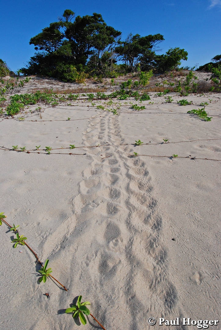
We found a
lot of Turtle tracks going up the beach where the large females had been laying
at night.
Whilst there
were lots of birds flying overhead, there wasn’t many nesting on the island or
in the trees.

Paul asked
Lisa to hold the wide angle camera while he took shots of the birds with the telephoto
lens camera. She walked off and started taking lots of photos, many of which
turned out great.


The shots
below are Lisa taking a photo of Paul who is taking a photo of Lisa….


We could see
a huge amount of cloud building back over the mainland and it looked like an
atom bomb cloud and we semi expected to get an afternoon storm.
The storm
didn’t eventuate but the clouds made for a different looking sunset.

We left the
next morning for a final push towards Lizard Island.
As we were
arriving we spied Spirit if Freedom (the 37m long dive charter boat Paul was
trip director on) leaving Watsons bay.
We called
Tony the captain and vowed to catch up when they return in 1 weeks’ time.
An aerial photo of Lizard Island gives you an idea of just how stunning the place is.

We entered
Watsons Bay and were surprised to find only 6 cruising boat in the anchorage.
We’ve got the
Australian Bureau of Meteorology to thank for that as they predicted a chance
of an early cyclone this year which had all the super conservative coastal
cruising yachts scurrying south well before we arrived.
It was the
least amount of boats we’ve ever seen at Lizard Island.
The anchorage
was calm and the water was very clear.

It was soooo
nice to finally go for a swim off the back of Lorelei and that afternoon we
swam, snorkelled and took the kayaks and SUP for a spin around the bay.
It’s the
first time we’ve been able to swim off Lorelei since Komodo and Sumba in
Indonesia back in February this year!
Paul got up
at 6am for another paddle and had the bonus of a great sunrise over the island.

The next day felt
like changeover day on board Lorelei.
We cleaned
and packed away all the Barra and estuary fishing gear and got out all the
diving gear.
Paul did a
full service on the scuba compressor and the generator at the same time (as
they both use Honda engines) and filled all our scuba tanks.
It was a bit
of a relief to have it working great after over a year of no use.
He also put
the recently serviced underwater camera systems back together which was
exciting as there were lots of new parts and features since their major overhaul
in the USA.

Despite being
ready to dive, the wind was strong and subsequently the viz was poor.
So instead we
went around to the side of the island past the research station and found a
great spot for Paul to go kiting.
There were 2
little bays – one perfectly protected to anchor the tinny in and a second one
that was perfect for Paul to do carve turns into.


The pass
between the main island and Palfrey Island had the wind funnelling through it
and was shallow with lots of coral reef making it great to kite over.


Paul doing ballet
kiting…….

An out-of-control
one-footed back-roll, Paul’s signature move…..

Paul left the
12 meter kite on the beach to dry and went for a swim with Lisa.
When he
returned the centre inflatable strut had gone down and we discovered the valve
had torn away and was leaking.
It didn’t
look like something we could fix and he was disappointed that his main kite was
now out of action.
That night it
blew up to 30 knots all night and by daybreak we were 100% full in battery
power as the wind generator had made a huge amount of power overnight.
With that
much wind it was time to kite again but this time Paul took his smaller
8 meter and
10 meter kites.
We also took
a few cameras and Lisa got some terrific shots with a wide angle lens and
polarising filter.


With a
smaller kite and the much windier conditions, Paul was able to get some bigger
jumps and high speed carves in.


Sadly he had
a big stack and snapped one of the inflation valves off the main tube and that
kite also deflated and was out of action.
We’d sailed
for 5 years and kited in over 12 countries without a single breakage to a kite
and now Paul had wrecked 2 of his 3 kites in just 2 days.
He was not happy…..
He was not happy…..
However back
on Lorelei, we had a look at both kites and were able to repair the 10m one. It
wasn’t perfect but it was good enough to get amongst it again when the wind
blew over 20 knots.
One afternoon
Paul went up the Cooks Look Lookout trail and found a great place to view the
sunset over the bay about 1/3 of the way up to the ridge.
The sunset wasn’t
as spectacular as the previous days but was still pretty good.


After 5 days
of 15-25 knot SE trade winds (even though it was now December…),
we downloaded
the weather to find a small one day break of 15 knots before it returned to
another week of 20-25 knots SE – again !!!!
We (along
with the other 15 boats now hunkered down in Watsons Bay couldn’t believe we
were still faced with more wind.
There were
many boats really wanting to get going south and many had Chrissy plans and
deadlines to keep.
We (along
with a few others) fortunately were in no rush and decided not to punch south
and just wait it out.
However most
of the yachts left, leaving only 4 in the bay.
We all
surmised that if the trade winds were still blowing and the temperature was a
very comfortable 27-31 degrees, then the monsoon season was still not here and the
cyclone risk very low.
So we spent
some time each day swimming at the beach out of the wind and exploring
different areas of the island.


The creek at
the end of the beach was fun to explore.
There were
loads of fish in the shallows and even some small black tip reef sharks
cruising around in just inches of water.


The girls
spent time learning how to weave baskets on the beach using palm fronds.

Someone had
also made a pretty cool sign.

We noticed
that every time we threw food scraps overboard from Lorelei, the fish
underneath would come up and quickly hoover them up.
We saw big
Trevally, Batfish and even Spangled Emperor near the surface.
So one
lunchtime we took some old bread down to the back swim platform and fed them.


Each Thursday
the 37 meter dive charter boat Spirit of Freedom comes into Lizard to do a
guest changeover.
We were
invited on board by Tony the captain who is an old friend.
Paul and Tony
used to work side by side on board with Tony as Captain and Paul as Trip
Director.
It was
awesome to catch up and see the changes throughout the boat.


Tony and Paul together on
the bridge again…..
It was cool
to see 3 of Paul’s photos that he took while working on board framed and
hanging on the walls.

We checked
out the new Yanmar engines which are about half the physical size of the old
Rolls Royce’s.

That
afternoon at 2pm we went for a walk.
It was only
supposed to be for an hour or 2 but we got sidetracked (twice) and ending up
stumbling home slightly intoxicated at 10pm!!!!
We took the
trail up to Chinaman’s ridge.
So much had
changed since we were there last.
One big
change was a new set of sign boards at the old ruins of Watson’s cottage.
For years it
was believed that it was the home of Robert and Mary Watson who arrived in 1879
to start a Bech-de-mer business, however the new boards indicate that
scientists and archaeologists now believe it may be the remains of a store
house from the crew of the ship Julia Percy that arrived 19 years prior to the
Watsons.
Mary Watson’s
diary describes a very different style of residence with less rooms and
thatched walls.
This was a
bit of a shock for Paul as for years he told the Watson’s story to the Spirit
of Freedom guests when he did a mid-week tour on the island.

The new signboards with
the building remains behind them
It was also sad
to see the deterioration of the building.
We can only
assume the 2 cat 5 cyclones that decimated the island and reef did a lot of
damage to the old walls and foundations.

This is a photo of
Paul’s dad George when we were here in 2011.
Note the stone walls of
the building back then compared to the photo from 2016 above
A little
further on we discovered a new bridge and elevated walkway going over the small
creek and mangroves.


George on the old timber
bridge in 2011
The views
looking over the island from Chinaman’s ridge are great.


From the
ridge we also watched a plane landing as it came in over the resort.


We walked
down to the Marlin Bar and noticed that it also had a makeover.
The Marlin has
been moved to a much better location over the bar and the outside areas were
beautifully manicured with lots of new outdoor furniture.

One the way
home we stopped on the beach and had a long chat with the other yachties which
was side-track no.1.
When up on
the ridge we noticed a cat called Liquid Desire had arrived.
We knew the
boat well as we had spent a lot of time with Anthony the owner diving, surfing
and wakeboarding in Palau.

We had hoped
it was still owned by him so on the way back to Lorelei we stopped to say
hello.

Anthony
and his dog Splash
Sure enough
it was still his and he now runs a charter business in the area.
The people on
the charter were old friends of his so we were invited on for a sunset drink on
the foredeck.
That turned
into 2 drinks - then 3 - then dinner – then lots of stories from us, Anthony
and his super nice friends Trish, John and Callum.
In the end we
were drinking spirits and watching the surf movie Thundercloud which is all
about “that day” at Cloudbreak, Fiji in 2012.
We had seen
loads of photos of the swell but never any video footage.

Despite being
a little dusty the next morning, we were up at 5:30am to tackle the land-based
highlight of Lizard Island - the Cook’s Look walk.
The walk is
rated on the signboard as “extremely difficult” and despite being strenuous,
it’s not so bad providing you do it early before it gets too hot.
On the way up
we stopped to watch the Sea Swift barge come into the resort to unload.

Despite many
of the larger trees having been destroyed by the cyclones, there were loads of
smaller Kapok trees full of the opened seed pods.


There was some
other great flora and fauna as well and Paul took a photo of a Pheasant Coucal
bird.
He’d tried to
photograph them on many occasions this year but never managed a clear or close
enough shot.


The view from
the ridge was great but from the summit overlooking the lagoon, it’s fantastic!

Looking back down along
the ridge


At the cairn
on the peak we signed the book.
It’s the 5th
time we have climbed the peak together over a period spanning 14 years.

On the way
back down we stopped for a long time at a great viewing rock and had a bite to
eat while admiring the view over Watsons Bay.

On the day of
the neap tides, we decided to brave the wind and go scuba diving.
The natural
choice was The Cobia Hole which is the premier dive site at Lizard Island. It
is not far from Watsons Bay and very protected from the SE winds and swell.
It was going
to be a bit of a test as it was our first dive in a year.
In fact it’s
the longest time that we have not dived since we learnt to dive over 25 years
ago.
Additionally
it was the first time diving from the new tinny and also with our rebuilt
underwater camera systems.
Lisa had some
minor issues with her camera and we took it back to the boat after just 10
minutes but Paul’s worked just fine.
Despite the
ordinary viz, we had a fun dive and were excited to have a Red Emperor that was
happy for Paul to get very close with the camera.


Overall the
new tinny was fantastic to dive from and gave us so much more room for dive equipment
and dry gear storage than our RIB.
Later that
afternoon we did a second dive at the Cobia Hole.
With the
flood tide and failing light we were hoping for better viz and more fish life.
Sure enough
that was the case and we had lots of schooling fish overhead.

Lisa’s camera
worked perfectly this time and she was able to get back into the macro
photography.
One big
highlight for her was to see a Solar Powered Nudibranch.
Despite
seeing these in the shallows in Indonesia, it was our first one in Australia
and a little deeper than normal at 17m depth.

The Red
Emperor was still there and had a friend with it – a large Permit or Snub Nosed
Dart.
Like the Red Emperor, they are also normally
very difficult to get close to and photograph.
Paul was
pretty happy to get a photo with both of them in the frame.


Lisa also
took some other fish shots.


We had 3
little Pilot Fish follow us everywhere we went.
Each time we
stopped they snuck into any gap they could find in our scuba gear making it
hard to get a photo of them.
We found if
we swam along mid water they would hover behind Paul and Lisa was able to get a
great shot of all three together.

With the dive
gear all sorted and working fine, we refilled the scuba tanks and were ready for diving on the Ribbon Reefs – if the bloody wind ever
abated….!!!!
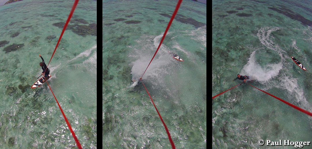
When the wind
came up again Paul had another session of Kiting.
He had
another attempt at repairing the 10m kite as he had found some much better
suited material to do the repair.
It came up as
good as new so we took it around to the pass to pump it up and try it out.
The wind was
only about 14-18 knots so Paul took a larger directional board for some fun as
it would plane a lot easier in the light winds than the smaller twin tip boards.
Additionally
he put a contour camera in the kite strings which made for a different outlook
kiting in the shallow coral filled pass.

Lisa checking the camera
was working just after launching


Carve turning around one
of the research station’s dive site moorings
Whilst he saw
loads of fish, a few turtles and smaller sharks, Paul didn’t even see the larger shark
in the photo below until he was doing the editing.

As the tide
dropped some of the coral was getting very shallow under the board


Even the stacks were
caught on camera…..


Sometimes an
image from the camera comes out looking weird and distorted.
This photo
was straight out of the camera with no editing.

So that’s it for
another month (and a bit) of our sailing adventure.
It’s our last
post of the year and we would like to wish everyone a fantastic festive season
and to all our avid followers – Thank you for your interest in our blog.
The stats are
the highest they’ve ever been and it makes all the effort worthwhile.
We’ll be back
in January 2017 as we continue our cruising, diving and exploring down
Australia’s magnificent East Coast.
See you in
the New Year!!!!!
Paul and Lisa
Hogger
Yacht
Lorelei.